Clark Fork River Plains Reach Assessment
Identifying restoration alternatives to improve conditions and restore natural channel processes while protecting critical infrastructure and economically important lands.
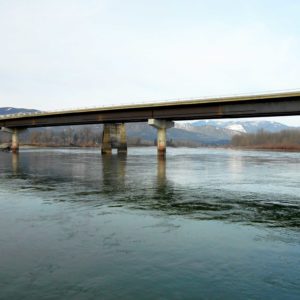
The 2014 Clark Fork River Plains Reach Assessment and Restoration Prioritization study included reviewing existing hydrologic data; conducting a geomorphic assessment, a Channel Migration Zone (CMZ) analysis, and a streambank erosion analysis; evaluating restoration alternatives; providing project prioritization; and reviewing permitting requirements and potential funding sources. During this study, a CMZ analysis was conducted along the 8-mile-long Plains Reach of the Clark Fork River to examine historic channel migration and evaluate future channel migration scenarios for this large, wandering gravel-bed river. The CMZ analysis for the Plains Reach included assessing the historical migration zone, developing an erosion buffer, identifying avulsion potential areas, and incorporating restricted migration areas. Based on this assessment, a suite of restoration alternatives and potential projects in 14 project areas were identified to improve conditions along the Plains Reach of the Clark Fork River and restore natural channel processes while protecting critical infrastructure and economically important lands. For the highest priority project identified, which was designed to protect the Plains wastewater treatment lagoons, RESPEC prepared a Renewable Resource Grant & Loan (RRGL) application for Sander’s County.
Stay in Touch