Drones
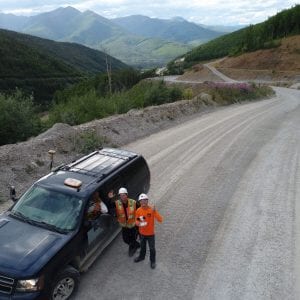
Mining
RESPEC has extensive experience using drones at mines of all types and sizes. From volumetric calculations to ortho mosaics and 3D modeling, our drones can be used to supplement, replace, and acquire new data at resource extraction locations. RESPEC’s surveyors are MSHA certified with years of experience.
Benefits of using drones at active mines:
• Drones can gather data without impeding workflow
• Impossible and hard to reach areas are now easily quantifiable with drones
• Large areas can easily be mapped and processed
• Drones improve safety, a necessity in the mining industry
Survey and Mapping
RESPEC’s drone pilots are at the forefront of survey and mapping-grade data collection in northern regions. Orthomosaics, point clouds, and contours to support — or replace — survey data collected by traditional survey methods can be obtained with drones. Then it can be combined for powerful visualization creation and modeling.
Our licensed land surveyors establish ground control points (GCPs), checkpoints, and TIN certification point to be used in our robust quality control process. Our staff of licensed land surveyors include FAA-certified drone pilots, ensuring the highest level of data collection. We use the latest technology to process the data and incorporate it into AutoCAD and ArcGIS formats.
Benefits of using drones for surveying and mapping:
• Cost and time is saved when compared to traditional methods
• Data is more safely collected in rugged terrain
• High-resolution imagery and 3D models allow for better decision-making
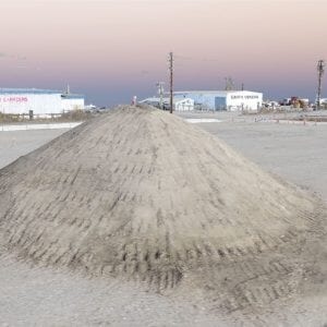
Volumetrics and Stockpile Analysis
Computing volume changes in stockpiles, material sites, or mining operations can be a tedious, potentially dangerous task. RESPEC’s use of drones allows operations to continue during the survey – uninterrupted. This is especially valuable in mining operations that involve heavy equipment.
We can measure any shape or size object with accuracy equivalent to traditional surveying methods. Any type of material can be measured, including aggregates, biomass, minerals, and even snow.
In addition to calculating volumes, drones allow our team to collect high-resolution photography of the site that can be used for 3D renderings and data modelling. The photos complement the survey data to visually show site changes over time.
Inspections
Why send someone into a dangerous situation when a drone can conduct the same inspection without risks to safety?
We use drones to inspect:
• Bridges, oil pads, ship docks, containment walls, or any other infrastructure
They can also be combined with terrestrial-based photogrammetry or 3D laser scanning.
• Façades, roofs, and buildings
• Construction sites
• Power, sewer, storm, water, fuel, and other linear utility features and infrastructure
• Tower inspections: cell, radio, radar, microwave, wind turbines, etc.
• Slope monitoring and reconnaissance
• RGB, infrared, and thermal capabilities for still imagery and video
Traffic Analysis
RESPEC utilizes a third party, web-based data analysis organization that processes drone videos to capture accurate, high-density data for your traffic evaluation needs.
Captured data includes:
• Traffic counting: highways, intersections, and roundabouts
• Traffic flow: occupancy, density, flow, and average speed
• Speed and acceleration
• Vehicle classification
• Traffic research: motion patterns, traffic congestion studies, and road safety
• Emissions: vehicle types and speed/acceleration
Planning and Design Concepts
A solid design starts with a clear plan. Using detailed images, renderings, and visualizations make a plan come to life.
We can use drone imagery and video to:
• Quickly gather site data
• Evaluate land uses
• Develop 3D models and data visualizations
• Simplify construction planning
• Collect time lapses and vantage points otherwise unattainable or cost prohibitive
• Integrate imagery and topography into renderings
• Create site specific proposals