Contribution-Based Fees for Water Management in the Sauk River Watershed District
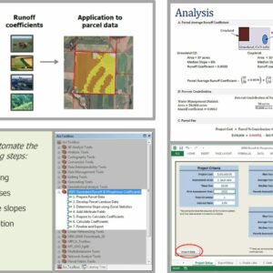
Watershed districts have the authority to fund projects based on benefits from or contributions to water quality issues by developing water-management units. Water-management units are subwatershed areas that are defined at a scale that more closely reflects the direct contributions and benefits to a resource targeted for improvement. In the Sauk River Watershed District (SRWD) of Minnesota, RESPEC developed a framework to fund runoff and phosphorus reduction practices within ten management units that the district established in their watershed management plan. For this framework, RESPEC refined an existing calibrated HSPF watershed model to develop runoff and phosphorus export coefficients that consider land use, soils, and light detection and ranging- (LiDAR-) derived slope. Using GIS, the derived coefficients were applied to the parcel through an analysis that split the parcel into its component land uses, and area-weights the component land-use coefficients to determine the parcel’s relative contribution to surface-water runoff and phosphorus loads within a management unit. Because of the frequency of parcels that are splits and transferred, RESPEC created an ArcGIS toolset to apply the HSPF-derived coefficients to new parcel datasets on an as-needed basis. Because the watershed spans multiple counties and component water management units, this toolset was divided into multiple steps. The product of this tool is an updated list of runoff and phosphorus coefficients for each parcel by management unit. Taking the output of the GIS toolset, a custom Excel-based workbook was developed to take the coefficients and distribute project costs to all parcels within the management unit being assessed based on the parcel coefficient. The coefficient generator and fee calculation tool allows the user to define project cost, assessment area, base fee, years of assessment, and interest rate. Changes to the parcel boundaries or land cover can be incorporated into the approach without rerunning the HSPF model, and ArcGIS tools were developed to automate this process.


Stay in Touch